Land Surveying
SLR offers comprehensive surveying services, leveraging extensive experience across various industries for topographical, bathymetric, and aerial imagery capture. Our surveying services extend to industries such as energy, waste management, planning and development, civil engineering, mining, quarrying and construction.
Overview
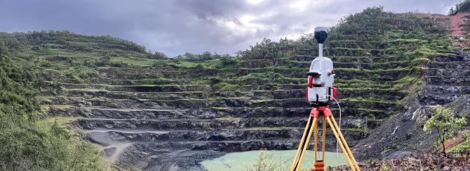
Our survey teams utilisecutting-edge technology such as terrestrial laser scanning, drone imagery capture, and remote-operated vehicle (ROV) bathymetric surveys. This combination allows us to deliver high precision and accurate data suitable for a wide range of applications, including quarry and mine design, engineering design, asset inspections, and environmental assessments. By owning and operating our aircraft, survey equipment, and processing software, we offer significant benefits in turnaround time, cost efficiency, and quality of information that seamlessly integrates into our client’s business plan.
Get in touch
Land Surveying Services
-
Remotely Piloted Aircraft Systems (RPAS) Drone Surveying
Through the use of our drones, we can offer high-definition aerial photography and videos; stockpile volumetric surveys and reporting; high resolution Digital Surface Models (DSMs); rectified orthophoto maps and plans; as well as contour and site attribute imagery.
-
Terrestrial Scanning
Our terrestrial scanning capabilities enable comprehensive on-ground solutions using global navigation satellite systems (GNSS), photogrammetry, and laser scanning. We provide invaluable insights through pit wall geotechnical monitoring and deformation analysis, facilitating proactive detection of movements or deviations over time, thus contributing to risk mitigation. This technology allows high-precision data capture, even in restricted areas such as indoor spaces or airspaces where drones cannot operate.
-
Bathymetric Surveying
Surveys of water bodies such as dams and rivers can be undertaken using our remotely operated survey vessel, to provide a 3D model of the subsurface profile and accurate calculations of the stored water volume.
-
CAD, 3D modelling and Design
From the collected survey data, we can produce soft and hard copy outputs as well as 3D visualisation plans.
Why SLR?
SLR services major national contracts, catering to clients with specific requirements for site surveys, setting out, void volume calculations, and design.
Our commitment to delivering high-quality, timely, and cost-effective solutions makes us a trusted partner in the surveying industry.
- Accurate: Through the use of real-time kinematics (RTK), our 3D elevation models offer precision with accuracy levels of 5cm laterally and 8cm vertically.
- Accessible: Survey data is available in full 3D via our secure online portal at any time. We can also provide data as drawings, filtered point clouds, or can integrate it with Vulcan or Surpac software.
- Fast: Depending on your needs, the time from capture to delivery can be as short as 1-2 days.
- Safe: Eliminates the need for ground surveyors in active pit areas, enhancing safety.
- Cost-effective: A fraction of the cost compared to traditional ground surveys.
Land Surveying Projects
Our Team Includes
-

Peter McGown
Technical Director, GIS and Information Services – Asia Pacific
-

Dominee Rye
Technical Director, Civil and Structural Engineering – Asia Pacific
-

Clayton Hill
Technical Director, Construction Materials & Services - Asia Pacific
-

Matthew Kirk
Geotechnical Engineer & Chief Remote Pilot, Groundwork, Part of SLR – Asia Pacific
-

Tristan Throup
Groundwork, Part of SLR – Asia Pacific, Groundwork, Part of SLR – Asia Pacific
Get in Touch
We're here to support you in Making Sustainability Happen. Get in touch for a collaborative discussion about what that could look like for your organisation.
Our locationsFill in the below form and we'll get you to the right place.
