
Assessing the Impacts of Climate Change on Federal Contaminated Sites
- Post Date
- 22 April 2024
- Author
- Sean Lynch
- Author
- Alexander Templeman
- Read Time
- 5 minutes
- Climate resilience planning & design

What is FCSAP?
The Federal Contaminated Sites Action Plan (FCSAP) was launched in 2005 as a 15-year initiative funded by the Government of Canada. In 2019, the program implemented the phase IV renewal for an additional 15 years. This renewal includes the consideration of climate change adaptation measures in the development of remediation/risk management (R/RM) strategies and long-term monitoring activities at new and existing federal contaminated sites.
Why include climate change considerations in FCSAP?
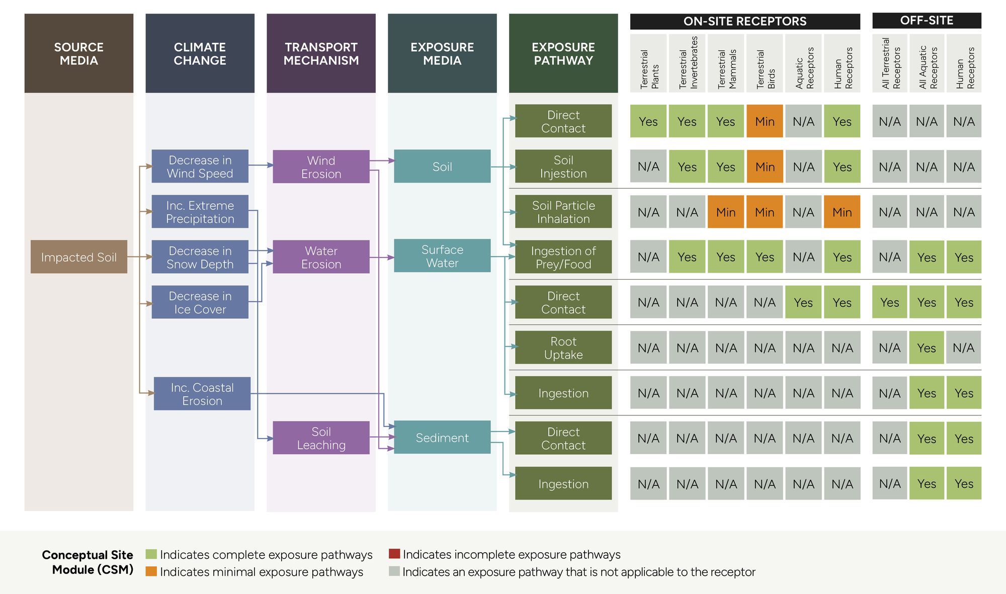
Climate change events such as heat waves, floods, and wildfires create risks and opportunities for the long-term management of contaminated sites. Not only are site elements and remediation techniques impacted by changing climate conditions, but source contaminants may also be affected. Shifts in climate parameters such as temperature and precipitation impact some remediation strategies, reducing their efficacy and the ability of site owners to manage risks. In certain settings, shifts in precipitation patterns and increased flood events can transport contaminants off-site. These changes can have significant environmental, operational, and financial consequences for site owners. By including climate change adaptation considerations in project R/RM strategies, site owners can evaluate how climate change events can alter exposure pathways, on-site and off-site receptors, as well as the fates of contamination (Figure 1).
How to consider climate change under FCSAP?
SLR follows the FCSAP 10-step Decision Making Framework to consider climate change (Figure 2). To support site owners and custodians with Steps 1 to 6, SLR develops a Climate Risk Profile for an individual site. The Climate Risk Profile is meant to answer the following questions:
- What climate change hazards are predicted at the site under current and future time horizons (e.g., near-term (current), mid-term 2050s, longer-term 2080s to 2100)?
- What is the variability in climate change hazard occurrence and intensity under low or high greenhouse gas (GHG) emission scenarios (e.g., Representative Concentration Pathways (RCPs) RCP 2.6 and RCP 8.5, or Shared Socioeconomic Pathways (SSPs) SSP1-2.6 and SSP5-8.5)?
- What is the likelihood of predicted climate change hazards occurring in the future?
- What potential climate impacts may occur on-site (e.g., increased rates of erosion and runoff, subsidence, etc.)?
Under Steps 7 to 10, SLR works with our clients to develop a site-specific Climate Change Risk Assessment. Our methodology for climate change risk assessments follows the high-level screening guide of the Public Infrastructure Engineering Vulnerability Committee (PIEVC) protocol. Under the PIEVC protocol, the assessment will generally consist of the following stages:
- Project Overview: Define the scope and objectives of the assessment
- Data Collection: Project elements, R/RM strategies, future time horizons, climate scenarios, and climate events
- Risk Assessment: Risk = Exposure x Likelihood x Consequence
- Reporting: Risk analysis and adaptation recommendations
The reliable climate change modelling data are used to develop the climate change risk assessment. The R/RM strategies developed for the site, and site elements (e.g., infrastructure and natural assets) are assessed to determine their exposure to climate change events. Each element is then assigned an individual risk score based on the exposure to climate change events, the anticipated likelihood of these events occurring in the future, and the determined level of consequence for each interaction. SLR’s climate resilience team works closely with our land quality team to determine the level of consequence for any identified risks. Risks are ranked from low to very high to prioritize critical risks effectively. Site-specific adaptation recommendations for enhancing R/RM or site elements are identified.

What makes SLR unique to tackle climate risk at contaminated sites?
At SLR we are committed to helping our clients address the material impacts of climate change. Leveraging our global presence and employing our One Team approach, we draw upon our diverse expertise across land quality and remediation, climate resilience, water resources, and risk assessment and toxicology. For FCSAP designated projects, we utilize this extensive experience and knowledge to develop realistic and actionable solutions that are tailored to meet the unique needs of site owners and custodians.
SLR provides unparalleled climate change expertise and tools through our partners at CLIMsystems. CLIMsystems’ Climate Insights provides users with the best available data for the geographical site under interrogation. This includes regional climate model (RCM) data available at temporal scales ranging from monthly to daily, and sub-daily intervals, enabling detailed analysis of an array of complex climate parameters. Data and outputs from Climate Insights are based on the Intergovernmental Panel on Climate Change (IPCC) guidelines in data modelling and application. All algorithms and datasets used in our modelling processes are thoroughly documented, tested, traced, and extensively peer reviewed by the CLIMsystems Scientific Advisory Panel and external professionals. By incorporating CLIMsystems Climate Insights tool into FCSAP projects we enhance our capabilities to develop rapid and scalable climate change risk assessments for our clients.